Thursday, September 15, 2022

PCT End Of Hike Summary

<--PREVIOUS

PCT End Of Hike Summary

"A Summary Of My PCT Thru Section Hike"


This is the hardest post to write.  I could probably update it and re-edit it every day for the next year and still feel like it isn’t an adequate summary.  My goal with this blog was to give an accurate glimpse each day of what it was like to be on the trail, or off the trail, and do it with a little humor.  Obviously, some days were more interesting than others, and many days were good days, and some days were not so good.  I tried to emphasize the positive, but with the overriding goal of giving an accurate depiction of each day, it wasn’t always possible to be entirely positive in my posts.  I think it’s important to understand that doing such a long hike has its share of struggles just like normal, every day life—in my mind, struggles are different than challenges.  Even the best of days on the PCT have challenges just due to the very nature of what you are doing.

While I did not complete a thru-hike of the PCT, as I desired, I did hike over 2,000 miles and almost 80% of the trail.  I feel like I hiked as much as I could, as far as I could without making any bad decisions to try to hike when and where it didn’t make sense to do so.  Sure, I could have hiked a few more miles here and there, but doing so would have put me in unfavorable, or even dangerous, situations.  One of my objectives for this hike was to not do anything that was intentionally stupid.  Safety is more important than trying to accomplish some glamorous goal.  I am mildly proud that I was perfectly on track with my detailed plan for the first 80 days and 1,500 miles, when I was stopped by my first fire closure near Mt. Shasta.  Without any trail closures, I firmly believe that I could have completed the entire hike nearly on schedule (the unexpected difficulties with bad trail conditions in Washington may have delayed me by a day or so).

Doing a long hike is interesting in how your mindset changes over time.  You start off as somewhat of a tourist, then transition into a determined hiking machine.  The first 1,000 miles felt like a long and interesting backpacking trip.  Everything after that, even when very scenic, felt like a mission.  After enduring a couple of months on trail, you really become determined to keep going and finish the hike, or as much of the hike as is practical.

A very common question all thru-hikers get is what part of the trail was a favorite. For me, it’s pretty easy, it is definitely the Southern Sierra (from South Kennedy Meadows to North Kennedy Meadows), especially the section that overlaps with the John Muir Trail (JMT).  There is amazing scenery, lots of water (at least thru early Summer), usually good options for campsites, lots of good trail, and great trail towns.  Washington has some really great scenery that is different than the Sierra, but the really bad trail maintenance detracted from the scenery; it’s hard to enjoy the scenery when you are just fighting the trail all day.  With improved trail maintenance and more tentsites, Washington would be a truly great place to hike, still hard, but great.  Unfortunately, I only hiked a couple of days in Oregon, and I was really looking forward to seeing the rest of it; so, judgement on Oregon will have to wait.

To finish off, below is a collection of random thoughts I collected on trail that never made it into any of my daily posts:

  • Doing a long hike does not make you an expert hiker, it just makes you a more experienced hiker.
  • Doing a long hike does not make you awesome, it just means you had an awesome experience.
  • Hiking is work, but it’s not “Work.”  While hiking is hard work, both physically and mentally, and you put in long hours doing it (usually 12-14 hours/day), it doesn't feel like a job.  A thru-hike, though, is definitely not a walk in the park.  The way I think of it is that a long-distance hike is hard, but your life while doing it is simple.
  • Hiking the PCT can’t be done without the help of others.  Most of all, you really depend on strangers for water caches and water tanks, and getting rides from the trail to towns and back to the trail.  And the trail magic that some provide, while not essential, is really very nice.
  • Similar to above, you very much rely on public resources to do this hike.  Living in suburban Southern CA all my life, I've never had much of a need to use public transportation, and I haven't really used public libraries for a long time.  Both of these things were incredibly helpful on this hike.  I definitely learned to appreciate, that for people without cars, public transportation is crucial.  Libraries, while not crucial to the hike, were very helpful, especially using their computers.
  • You can go a long time without showering or bathing with no negative health effects.  You can also wear the same clothes 24/7 for many days with no negative health effects.  However, three things hikers look forward to most when getting to town are showering, laundering, and eating.
  • 50X The Minimum Recommendation: Health Experts say that a person should get at least 75 minutes of vigorous exercise weekly.  One way to put a thru-hike in perspective is that the average thru-hiker is exceeding the 75 minutes weekly by about 50X that amount.  From a fitness perspective, thru-hiking is definitely overkill.
  • Flying and driving make the world seem small, hiking reminds that the world is large.
  • Leaving Plato’s Cave: Sometimes while hiking I thought of the allegory of Plato‘s Cave (Google it if you don’t know it).  An aspiring thru-hiker spends a fair amount of time looking at photos and videos of the trail, reading journals and blogs and books, and looking at maps.  But all of these things are just shadows on the cave wall, a semblance of reality that leads to reverie.  Being out on the actual trail, you see the real sites, you smell the real air, you feel the heat of the sun and the absence of it, you feel the wind, you feel the force of gravity going both up and down and even when it’s flat, you feel and see your legs post-holing deeply into soft snow, you feel hunger and thirst, and the real relief that is brought by food and water.  While shadows on a cave wall can be interesting, and even entertaining, it’s much better to actually be out on the PCT.  To truly understand what it’s like to do a long distance hike, you actually need to do one.  It also reminds me of a Native American Indian proverb: “Tell me and I’ll forget.  Show me, and I may not remember.  Involve me, and I’ll understand.”

<--PREVIOUS


Wednesday, September 14, 2022

PCT Day 116

<--PREVIOUS                                                                                                            NEXT--> 

PCT Day 116, 05 September 2022 (Monday)

"An Early, But Natural End"


Start Location:

Campsite Near Mt. Hood

Destination:

Timberline Lodge, Then To Portland

PCT Miles Day 116:

5.6

Cum PCT Miles:

2,057.1

Non-PCT Miles Day 116:

0.3

Cum All Miles:

2255.2

PCT Miles Remaining:

595.7


Elevation Gain Day 116:

1,476

Cum Elevation Gain:

366,307


Timberline Lodge on Mt. Hood, OR is another one of the iconic, well-known, and much looked forward to stops along the PCT.  For one thing, it is easy to get to and from the lodge using the Mt. Hood Express Shuttle service, so it is a natural place for people to get off and rejoin the trail.  If rooms are available, it is also a popular place to spend the night.  Lastly, and probably most importantly, the lodge has a very good, and somewhat reasonably priced, breakfast buffet.  It is all you can eat, so thru-hikers definitely get their money’s worth at the buffet.  I had a short hike to get to the lodge this morning, and then headed straight to the buffet. I was pretty satisfied by the time I was finished eating.


There is a nice, large public space to hangout right outside the buffet room, and there is good cellular connectivity here.  So, before leaving the lodge to continue hiking, I decided to check to see if there was any change in status on fires and trail closures.  Unfortunately, there was a new closure in Oregon, just a few days hiking south of Mt. Hood.  The Cedar Creek fire is a complex of lightning-caused fires that has been under watch for a while.  Sometime in the last day, the fire got close enough to the PCT that about 40 miles of trail in this area has been closed.  This is bad news for me, because this is the area in which I was heading, and where I was going to get my next resupply.

This new fire closure meant that I had a big decision to make.  Hike for a few more days until I got to the northern part of the closure, and hope that the closure would be lifted, or get off the trail.  I sat at the lodge for a while contemplating this decision.  If I continued hiking, and the closure was still in place in a few days, I would be stuck in a much more remote area of Oregon.  I would have very limited food left, no place to resupply, and very limited, difficult transportation options to get out of the area.  Also, it's likely there would have been a lot of smoke in this general area.  I decided this didn’t seem like a very good idea.

I thought about maneuvering around the fire closure and hiking south of the closure. But because of all the active fires in California and Oregon, there was no guarantee I would be able to get very far.  Additionally, and honestly, I was getting a little tired of spending so many days off trail, not hiking, getting around various closures on the trail.  I came out here to hike the PCT, not to spend day after day trying to find some form of transportation to get to and from remote areas of the trail.  On the other hand, if I got off the trail at Timberline Lodge, there is easy transportation to Portland, and then to home.  Also, the section of trail that I haven’t hiked is one continuous section from Mt. Shasta, CA to Mt. Hood, OR; both being relatively easy to get to and from. So, if I decide to go back and complete the hike, it will be a pretty clean trip, assuming no closures when I do it.

After thinking through things, the decision, while hard, seemed pretty clear, it would be best to get off the trail and end my hike for now.  I would no longer be a PCT thru-hiker, but a section hiker.  But these days you have to have some good luck to complete the whole trail in one continuous hike.  And my luck ran out.  It’s a very strange feeling, it’s such a sudden and abrupt end to the hike, but one that is not entirely unexpected.  I knew from the beginning that fire closures were a real possibility.

With the decision being made, there was no time to waste.  I checked the schedule for the Mt. Hood Express Shuttle, and there was one leaving in about 30 minutes to Sandy, OR.  From Sandy I took a local bus to Gresham, OR, and then the metro train to Portland.  After getting to Portland, I was able to book a flight to Orange County for the next morning.  It’s not the end I hoped for, but it’s the one I got.   I will do one more blog post after this to try to summarize my hike.

“If all misfortunes were laid in one common heap whence everyone must take an equal portion, most people would be contented to take their own and depart.” - Socrates.


Mt. Jefferson, in the morning, from the trail


Some mountains, from the plane (from tomorrow), in Oregon I would have hiked by if not for the fire closure (I believe these are the Three Sisters).

 <--PREVIOUS                                                                                                        NEXT-->

PCT Day 115

<--PREVIOUS                                                                                                             NEXT--> 

PCT Day 115, 04 September 2022 (Sunday)

"State Of Confusion"


Start Location:

Wilderness Campsite

Destination:

Campsite Near Mt. Hood

PCT Miles Day 115:

23.2

Cum PCT Miles:

2,051.5

Non-PCT Miles Day 115:

0.4

Cum All Miles:

2249.3

PCT Miles Remaining:

601.3


Elevation Gain Day 115:

5,229

Cum Elevation Gain:

364,831


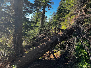
I’m confused. I thought I was in Oregon, but it feels like I’m in Washington.  First of all, the trail has been very steep these first two days in Oregon with over 11,000’ of elevation gain.  Additionally, the first part of the day had several miles of really bad obstacles, and bad “car wash,” bushwhacking that completely soaked me.  There was one stretch of only about 150 yards where I had to take off my pack five times to shove it under a downed tree and either crawl under the tree myself or climb over the top of the tree.  After that, the trail improved.  Good thing, because I was getting pretty frustrated with the trail.

Due to the early trail difficulties, I didn’t get to Timberline Lodge by the end of the day as I’d hoped.  However, I did have a really nice campsite with a great view of Mt. Hood all to myself.  And it was warm today so I was able to dry things out during the middle of the day.


Where am I, back in Washington?


Sandy River


The backside of Mount Hood topped with wispy, form-fitting clouds


Campsite with Mt. Hood behind the trees


<--PREVIOUS                                                                                                            NEXT-->

Tuesday, September 13, 2022

PCT Day 114

<--PREVIOUS                                                                                                            NEXT--> 

PCT Day 114, 03 September 2022 (Saturday)

"This Should've Been All Downhill"


Start Location:

Cascade Locks Via Portland, OR

Destination:

Wilderness Campsite

PCT Miles Day 114:

20.9

Cum PCT Miles:

2,028.3

Non-PCT Miles Day 114:

0.6

Cum All Miles:

2225.7

PCT Miles Remaining:

624.5


Elevation Gain Day 114:

5,791

Cum Elevation Gain:

359,602


As I did when I started hiking Washington, I took the Columbia Gorge Express bus from Portland out to Cascade Locks.  Again, I got a large soft-serve ice cream cone from Eastwind Drive-in.  Then, I went to the post office to pick up my resupply box.  As the postal clerk promised me yesterday, I knocked on the door and they, very nicely, retrieved my box for me.

Oregon is supposed to be the easiest state to hike on the PCT.  But stats wise, today was as difficult, or even more difficult, than most days in Washington.  The first 10 miles were very steep, and, thus, very hard.  But, this isn’t Washington, that’s just what happens when you start out at near sea level.  The trail today was much better than the vast majority of the trail in Washington.  So, even though it was hard, the miles went by faster.  Funny thing is, if I had been doing this part going northbound, as per my original plan, instead of southbound (SOBO), today would’ve been an easy downhill hike.

It was overcast and cool all day. It’s supposed to warm up tomorrow, I guess we’ll see.


A PCT monument and the Post Office in Cascade Locks


The Columbia River from the Oregon side of the PCT


Wahtum Lake


A nice view of Mt. Hood

<--PREVIOUS                                                                                                            NEXT--> 


PCT Day 113

<--PREVIOUS                                                                                                            NEXT--> 

PCT Day 113, 02 September 2022 (Friday)

"Portland"


Start Location:

Portland

Destination:

Portland

PCT Miles Day 113:

0

Cum PCT Miles:

2,007.4

Non-PCT Miles Day 113:

0

Cum All Miles:

2204.2

PCT Miles Remaining:

645.4


Elevation Gain Day 113:

0

Cum Elevation Gain:

353,811

 
Not much to say today.  I’m in Portland getting ready to go back out to Cascade Locks tomorrow to start hiking again.  I had a little drama today, though.  I thought I might have to go to Cascade Locks Post Office today to pick up my resupply box, because they are closed on Saturday.  I hadn’t noticed before that this particular location is closed on Saturday, most post offices are open for at least a few hours on Saturday.  Thinking that the Google Maps info might be incorrect, I called the post office, and they confirmed they are closed on Saturday.  However, they are there working in the back, and will retrieve hiker boxes, you just have to knock on their door.  Whew, that saved me an unwanted, extra trip.

<--PREVIOUS                                                                                                            NEXT-->

PCT Day 112

<--PREVIOUS                                                                                                            NEXT--> 

PCT Day 112, 01 September 2022 (Thursday)

"Any Way West"


Start Location:

Wenatchee

Destination:

Portland Via Seattle

PCT Miles Day 112:

0

Cum PCT Miles:

2,007.4

Non-PCT Miles Day 112:

0

Cum All Miles:

2204.2

PCT Miles Remaining:

645.4


Elevation Gain Day 112:

0

Cum Elevation Gain:

353,811

 
So, this blog is supposed to be about a thru-hike of the PCT.  But here is a brief summary of the last couple of days:  Short hike to High Bridge, shuttle bus to Stehekin Pastry company, short walk to Stehekin Landing, express ferry to Chelan, regional bus to Wenatchee, Amtrak train to Seattle, then rental car to Portland.  The next couple of days will involve more buses and metro trains.


Taking the Amtrak from Wenatchee to Seattle

<--PREVIOUS                                                                                                            NEXT--> 


PCT Day 111

<--PREVIOUS                                                                                                            NEXT--> 

PCT Day 111, 31 August 2022 (Wednesday)

"The Completion Backward Principle"

(You probably have to be around my age to get this reference)


Start Location:

Bridge Creek Campground

Destination:

Wenatchee Via Stehekin and Chelan

PCT Miles Day 111:

0

Cum PCT Miles:

2,007.4

Non-PCT Miles Day 111:

6.4

Cum All Miles:

2204.2

PCT Miles Remaining:

645.4


Elevation Gain Day 111:

0

Cum Elevation Gain:

353,811


Note: Total miles today was 4.9 (plus 1.5 miles off the trail), but are not official PCT miles; also, total unofficial elevation gain was 718’.

It was a pretty short hike this morning to get from Bridge Creek Campground to High Bridge.  This completed my mini yo-yo hike.  High Bridge is where you catch the shuttle down to Stehekin.  I was a little, but not a lot, surprised that, even though I got there early, there were already about 20 other thru-hikers waiting for the bus.  By the time the main shuttle bus came, there were probably close to 50 people waiting.  Luckily, the main bus is an old school bus that was large enough to get everyone on board.  At $10 a pop, the bus made about $500 for the nine mile drive down the road.  Not bad.

I got off the bus at the Stehekin Pastry Company and got plenty of goodies to eat, including some morning ice cream.  Then I walked about 1.5 miles down the road to get to Stehekin Landing.  I had good timing as I bought a ticket for the express ferry, and only had to wait about an hour for it to depart.  It was important to catch this ferry as it is approximately two hours to get across the long Lake Chelan vs. four hours for the normal ferry, which didn’t depart until later in the day.  If I had to take the normal ferry, I would not have gotten to the town of Chelan early enough to catch the regional bus to Wenatchee, WA.  As it was, my timing was good again, as after getting off the ferry, I only had to wait about 30 minutes to catch the free bus to Wenatchee.

Wenatchee, is a larger town (small city?) and has an Amtrak station.  I am spending the night in Wenatchee and will catch the train to Seattle in the morning.  There is an A&W Root Beer close to my hotel, and it is one where they still make the root beer at the restaurant vs. just using syrup.  So, of course, I had to get a large root beer float.


Howard Lake


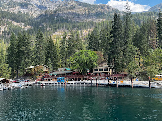
Stehekin Landing from ferry boat


<--PREVIOUS                                                                                                                NEXT--> 


PCT End Of Hike Summary

<--PREVIOUS PCT End Of Hike Summary "A Summary Of My PCT Thru Section Hike"   This is the hardest post to write.  I could prob...