Wednesday, June 22, 2022

PCT Day 41


<--PREVIOUS                                                                                                             NEXT--> 

PCT Day 41, 22 June 2022 (Wednesday)

“Weather Or Not”


Start Location:

Wilderness Campsite

Destination:

Bishop

PCT Miles Day 41:

0.1

Cum PCT Miles:

789.0

Non-PCT Miles Day 41:

7.6

Cum All Miles:

847.3

PCT Miles Remaining:

1,863.6


Elevation Gain Day 41:

0

Cum Elevation Gain:

139,996


Today was about as nero (near zero) as nero gets, with only 0.1 miles hiked on the PCT.  However, I did hike 7.6 miles over Kearsarge Pass to Onion Valley Campground, where I hoped to get a ride to either Independence or Bishop.  I am a day ahead of schedule, so I am planning on spending the night in Bishop, and then going back to Independence tomorrow.  Today is basically an unplanned town day.

There was a surprise this morning.  As I was packing up things inside my tent, I saw a white speck hit right outside my tent.  It was either hail or a very compact snowflake.  I’ve been out here over 40 days now, and this is the very first bit of precipitation.  I didn’t know whether it was a sign of a much larger storm or just morning moisture.

I decided the best thing to do would be to get packed up and hike as quickly as possible up and over Kearsarge Pass and down to the Onion Valley Campground.  I figured it would take me about 90 minutes to get to the top of the pass and about the same to get down to Onion Valley.  Since I am now low on food, I didn’t want to take the chance of being where I was in a much larger storm and being stuck there for more than a day.  I didn’t think there was a huge amount of risk in hiking through a snow storm for a couple of hours, even though part of it was going over a high pass.

As I started hiking, the sleet, hail, and snow started coming down more heavily.  However, it didn’t seem to be accumulating or sticking on the ground.  As I kept hiking, and gaining elevation, it started snowing even more heavily, and now it was sticking and accumulating.

I was concerned that if it started snowing very hard, the trail could be obscured.  However, I still thought there was more of a risk of not going forward than going forward.  It was a good decision.  As I got near the top of the pass, the snow lightened.  I was pretty motivated, and quickly made my way down the mountain.  Soon enough I was at Onion Valley.

My next challenge was getting a ride down the 13 mile road to either Independence or Bishop.  Onion Valley is a very busy trailhead. But I was there in the morning when the odds of getting a hitch down the road were much smaller than they would be later in the afternoon when people were finishing their day hikes.

After about half an hour, I saw a lady, Paula, running down the trail with her dog.  She saw me standing by the road with my pack and asked me if I needed a ride.  Of course I enthusiastically said yes.  It turns out, she was actually going right to Bishop.  So it was perfect.  She was a local and very knowledgeable about the outdoors and hiking.  The trail provides once again.


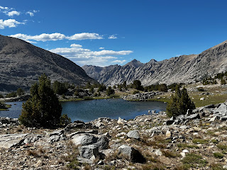
Bullfrog Lake from Kearsarge Pass Trail

 
New snow on the Kearsarge Pass Trail


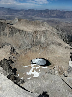
Atop Kearsarge Pass

 
Interesting mosaic outside the Bishop Public Library


<--PREVIOUS                                                                                                             NEXT-->                             


PCT Day 40

 <--PREVIOUS                                                                                                             NEXT-->

PCT Day 40, 21 June 2022 (Tuesday)

“Apex Treader”


Start Location:

Crabtree Meadow

Destination:

Wilderness Campsite

PCT Miles Day 40:

22.6

Cum PCT Miles:

788.9

Non-PCT Miles Day 40:

2.4

Cum All Miles:

839.6

PCT Miles Remaining:

1,863.7


Elevation Gain Day 40:

5,445

Cum Elevation Gain:

139,996


What a 1-2 punch. First, Mount Whitney yesterday, then Forester Pass today.  The highest point I’ll get to on this hike, and the highest point on the PCT trail.

I have to say that whoever designed and built the trail leading up to Forester Pass, and especially going to the top of Forester Pass, did a great job.  When you’re near the base of the pass looking up, it doesn’t seem possible that there is a trail there, but there is actually a very good trail.

Today was another perfect weather day.  And the scenery was spectacular almost everywhere you looked.  It was the kind of day where you could take a great picture every few minutes.

I was going to spend the night at Charlotte Lake, which is not on the PCT, but decided to just get water there and find a spot back up by the PCT trail so I would have a shorter hike over Kearsarge Pass in the morning.  This decision was made much easier because of the fact that Charlotte Lake was also swarming with mosquitos, by far the most I've seen yet on this hike.

I am a day ahead of schedule again, so I’ll probably go to town a day early, but return to the trail on Friday as scheduled in my plan.


Morning scene, on the way from Crabtree Meadow to Wallace Creek


Wallace Creek, first longish water crossing...it was really just a long rock hop

 
Mt. Whitney from a different angle


Tawny Point, a little different look out here


Forester Pass ahead


Finally, a little patch of snow on trail


Getting closer to Forester Pass


Trail near the top of Forester Pass


Atop Forester Pass


Tarns at the base of Forester Pass

 
Skypilot. There is actually a geologic feature in Yosemite, Skypilot Col, named after this flower.


Unnamed pond...the photo doesn't do it justice, you could just sit there and look at it all day

 
East Vidette

 
Bubbs Creek

 
From near Vidette meadow

 
  <--PREVIOUS                                                                                                             NEXT-->

PCT Day 39

<--PREVIOUS                                                                                                             NEXT-->

PCT Day 39, 20 June 2022 (Monday)

“Whitney, Finally”


Start Location:

Wilderness Campsite

Destination:

Crabtree Meadow

PCT Miles Day 39:

2.4

Cum PCT Miles:

766.3

Non-PCT Miles Day 39:

17.1

Cum All Miles:

814.6

PCT Miles Remaining:

1,886.3


Elevation Gain Day 39:

251

Cum Elevation Gain:

134,551


Today was my fourth attempt to hike Mt. Whitney. Dating back to my Boy Scout days, I have been denied due to weather, fire, and medical reasons.   I finally got there today, and it was worth it.  It was a perfect hiking day.  The temperature was comfortable, the winds were low, and I didn't even put on a jacket until I got to the top...unusual for being at over 14k feet.  The 360 degree views were really spectacular.  And just like Half Dome, you are surprised by how expansive it is at the top; you could spend an hour just walking around up there.  Mt. Whitney is not officially on the PCT, so I didn't get many official PCT miles in today.  But the ~15.5 miles hiking Whitney still made a full day.  Also, Whitney is, obviously, the highest point I'll get to on this hike, but it is not the highest point on the PCT, that is tomorrow with Forester Pass.

All in all, a really great day.  I would highly recommend to anyone that doesn't mind overnight backpacking, to go up Whitney from the west side, it is a great trail.


Campsite last night with Mt. Guyout as the backdrop


Part of Crabtree Meadow

 
Timberline Lake, on the trail to Mt. Whitney

 
Guitar Lake at water level

 
Marmot trying to hide from me

 
Guitar Lake from high up...funny, from up here it looks like a cello


The Mt. Whitney Trail

 
Neat rocks

 
The meeting point of hikers coming up from Whitney Portal (east to west) and the PCT/JMT (west to east)


One of the famous "windows" leading up to Mt. Whitney


Another one of the windows leading up to Mt. Whitney


Hut at the top of Mt. Whitney


The very top of Mt. Whitney

 
From the top of Mt. Whitney, I believe that is Iceberg Lake


Panoramic from atop Mt. Whitney

 
From the Mt. Whitney Trail

 
Lower and Upper Hitchcock Lakes from high up the Mt. Whitney Trail


Stream feeding into Guitar Lake

 <--PREVIOUS                                                                                                             NEXT-->


PCT Day 38

<--PREVIOUS                                                                                                             NEXT-->

PCT Day 38, 19 June 2022 (Sunday)

“Touching The Surface”


Start Location:

Wilderness Campsite

Destination:

Wilderness Campsite

PCT Miles Day 38:

24.9

Cum PCT Miles:

763.9

Non-PCT Miles Day 38:

0.6

Cum All Miles:

795.1

PCT Miles Remaining:

1,888.7


Elevation Gain Day 38:

4,224

Cum Elevation Gain:

134,300


I got another late start due to the cold.  In my defense, it’s hard to get going when your fingers are so numb you can’t tie shoelaces.  But it was also another bluebird day, with the added bonus of improving scenery, as can be seen in the photos.

It was also another good acclimatizing day with the vast majority of hiking done above 10 and 11,000 feet.  I am now 13 miles ahead and should do Mt. Whitney tomorrow, a day earlier than planned.  It stayed warmer longer today so I was able to do a few more miles, but in the evening it started getting pretty cold again.

A few well-known things that can affect the difficulty of a hike are the total miles hiked, the total ascent and descent, the elevation at which the hiking is done, and the weather.  But, one thing that is rarely talked about, is the surface on which the hiking is done.  In my experience, the surface can drastically affect the pace at which one can hike.  Today’s surface was mostly ideal, with hard-packed sand and dirt.  This helped in getting some good miles done today.  Of course, no long stretch is completely ideal.  There were several miles of deeper sand and tricky rock.

It’s relatively easy to estimate how many miles you can hike each day based on the well-known factors. But, that added factor of surface can really really trip you up (no pun intended), or speed you up.

My least favorite surface is unorganized and non-uniform talus and scree.  You have to be really careful on this stuff, and it’s also hard on the feet and shoes.  My second least favorite is deep sand.  Not only does it slow you down, but it gets inside your shoes, and can cause blisters if you do not regularly takeoff your shoes and get the sand out.  There are a bunch more varieties of surface, obviously, but you get the idea.

I’ve been running into more non-PCT backpackers, as was expected.  And, also as expected, seen a lot more PCTers from the Kennedy Meadows Bubble.  This should start spreading out more over the next few days as a lot of hikers have very different plans for hiking Mt. Whitney or not, where to exit the trail to go to town and which town to go to.

I’m having maybe my favorite backpacker meal tonight, spaghetti with meat sauce.


Trailmaster Peak

 
Chicken Spring Lake, the first Sierra lake on the PCT

 
View from today

 
Kaweah and Black Kaweah Mts, among others

 
Rock Creek, best flow of water yet in the Sierra


<--PREVIOUS                                                                                                             NEXT--


PCT Day 37

  <--PREVIOUS                                                                                                             NEXT-->

PCT Day 37, 18 June 2022 (Saturday)

“Mooving Day”


Start Location:

Campsite at S. Fork Kern River at Monache Meadow

Destination:

Wilderness Campsite

PCT Miles Day 37:

22.6

Cum PCT Miles:

739.0

Non-PCT Miles Day 37:

0.8

Cum All Miles:

769.6

PCT Miles Remaining:

1,913.6


Elevation Gain Day 37:

5,082

Cum Elevation Gain:

130,076

 
Just as I thought, last night was very cold.  And it’s very cold this morning.  In fact, I noticed there was some ice on top of the water in the calmer parts of the Kern River.  You know if river water has ice on it, it has to be really cold.

I got a much later start than usual, and than what I wanted.  But it was just so cold I couldn’t use my fingers very much, so it was hard to get everything ready to go.

It seems that every day something interesting or new happens.  Today as I was walking up the trail, I looked up and saw a cow.  It’s not that unusual to see cows--I guess it would be more correct to say cattle--on some parts of the PCT, but I didn’t expect to see them here.  And it wasn’t just one or two, it was a small herd of several dozen, broken into smaller groups.

It was a little bit of a sketchy situation.  You would think that cows on the PCT would be used to seeing hikers.  But some of them seem spooked when they saw me, and some of them weren’t looking at me in a very friendly way.  Each time a group of cows would come, I would move off the trail as much as possible.  But even then, some of them would still get spooked.  Maybe it was because there were some calves in the herd.  But more than once I thought I might get charged by one of the older cows.  After a while, they had all passed.  But it did slow me down a bit.

Weather wise, it was a bluebird day, with comfortably cool to warm temps, until later in the day when it started getting cold again.  It was pretty pleasant Sierra scenery today, but nothing too spectacular.

Even with the late start, it was a day to move and get miles in.  I did five more than planned, and I’m now about 8 miles ahead.  Once again, I could have gotten more miles in today, but I find myself setting up camp earlier than usual due to the cold temps in the late afternoon.  A lot of the hiking today was done above nine and ten thousand feet, so it was a good acclimatizing day.  It’s going to be another very cold night.


Cows on trail


Typical trail today

 
Owens Dry Lake Bed

 
<--PREVIOUS                                                                                                             NEXT-->

PCT End Of Hike Summary

<--PREVIOUS PCT End Of Hike Summary "A Summary Of My PCT Thru Section Hike"   This is the hardest post to write.  I could prob...