Sunday, July 31, 2022

PCT Day 71

<--PREVIOUS                                                                                                             NEXT--> 

PCT Day 71, 22 July 2022 (Friday)

“Split Decision”


Start Location:

Silver Lake Junction

Destination:

Myrtle Flat, North of Belden

PCT Miles Day 71:

20.5

Cum PCT Miles:

1,293.7

Non-PCT Miles Day 71:

0.7

Cum All Miles:

1386.9

PCT Miles Remaining:

1,358.9


Elevation Gain Day 71:

3,130

Cum Elevation Gain:

229,940


Today the plan was to get to the Belden Town Resort, pick up my resupply package, do the usual town stuff like laundry and shower, and spend the night there.

However, I started rethinking this plan after taking into consideration that there is a very long, substantial climb getting out of Belden (~5,500 ft. elevation gain over 14 mi).  Also, it is very hot, probably over triple digits.  So, I thought it’d be better to do the climb when the temps were a tad bit cooler.  And if I stayed at the resort, I was going to have to sleep in my tent in their campground.  So, if I was going to sleep in my tent anyway, why not just sleep in my tent on the trail.  So, I decided that it would be best to split the big climb into two parts; part of it this afternoon, and the rest tomorrow morning.


This would mean getting to Belden in the late morning, spending several hours there, and then hike for a few hours in the late afternoon and get a portion of the big climb done.  Then, I would complete the rest of the big climb the next morning.


However, there was a little snafu with my resupply package.  It wasn’t at the Belden Town Resort where it was supposed to be.  The place in La Habra that shipped the package, did not follow the instructions and send it via UPS, they sent it via USPS.  This might not ordinarily seem like a big deal, but in these small towns, it is a big deal.  In many small towns, all the mail gets delivered to the local post office, or authorized postal representative, and that’s where people pick up their mail.  To get packages delivered directly to a specific address in some of these small communities, they need to go via UPS or FedEx.


A bit stymied by no cellular connection and bad Wi-Fi once again, I did ultimately find out that the package was sent to the local post office, located at the Caribou Crossing business, which was about 2 miles down the highway.  Lucky for me, the owner of Caribou Crossing offered to come pick me up and take me back to get my package.   Did I ever mention the trail provides?  While there, I also got some food, including a homemade strawberry shake, did laundry, and took a shower.  Then the owner gave me a ride back to the Belden Town Resort.


So, while I lucked out, all this took longer than I had planned.  But, I still got back out on the trail in the afternoon and did almost half of the big climb out of Belden.  I am glad I decided to hike out this afternoon, but I was not thrilled with my tent site, which is in the middle of burnt trees and very fine, sooty soil.   Camping in regular dirt is one thing, but camping in this stuff is another level of bad.  It was like sleeping in an uncleaned fireplace.


This is my third day of hiking through the remains of the Dixie fire.   It’s almost impossible to find a tent site that’s not surrounded by dead trees that are basically just standing charcoal.  It’s not ideal because the trees can be very dangerous.  In fact, the last two nights I’ve heard branches falling from trees, and I had a branch fall about 30 feet in front of me as I was hiking down to Belden this morning.  It’s just a good thing it has not been windy at night, that would be very bad in an area like this.


The next 9–10 days are logistically tricky.  So, while it’s not my best plan yet, I am going to just hike as many miles as I can for the next week, get food where I can, and see where I’m at.  I don’t know how this is going to work out yet, but based on how things have worked out so far on this hike, I think I’ll be OK.

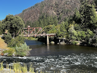
Historic Belden Bridge and North Fork Feather River

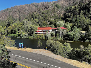
Belden Town Resort and North Fork Feather River

 
<--PREVIOUS                                                                                                             NEXT--> 

PCT Day 70

 <--PREVIOUS                                                                                                             NEXT--> 

PCT Day 70, 21 July 2022 (Thursday)

“Looking Very Gnatty”


Start Location:

Wilderness Campsite

Destination:

Silver Lake Junction

PCT Miles Day 70:

26.1

Cum PCT Miles:

1,273.2

Non-PCT Miles Day 70:

0.7

Cum All Miles:

1365.7

PCT Miles Remaining:

1,379.4


Elevation Gain Day 70:

5,724

Cum Elevation Gain:

226,810


Not much to say today. It was very warm, I was pouring water over my head every chance I got.  I was walking in and out of burn areas the first half of the day, and mostly healthy forest the second half of the day.  There were lots of big climbs today, but nothing very memorable.

Where I ended up stopping was kind of a mix between burnt forest and healthy forest.  And I’m not sure why but some of these burn areas seem to attract a lot of gnats and mosquitoes (perhaps healthy vegetation acts as a barrier?).  In fact, the last few miles of the trail today was maybe the most gnats I’ve seen in my life.  It was unavoidable to choose a tentsite in the general area that wasn’t swarming with gnats.  Oh well, the tent site itself was OK, and I managed to get in and out of the tent without any gnats getting in.


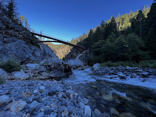
Middle Fork Feather River

Keep your eyes up and open in the burn areas, or you’ll get snagged faster than a cheap zipper

  <--PREVIOUS                                                                                                             NEXT-->                                                                                    

PCT Day 69

<--PREVIOUS                                                                                                           NEXT--> 

PCT Day 69, 20 July 2022 (Wednesday)

"Escalator To Nowhere"


Start Location:

Wilderness Campsite Near Little Jamison Creek

Destination:

Wilderness Campsite

PCT Miles Day 69:

31.1

Cum PCT Miles:

1,247.1

Non-PCT Miles Day 69:

0.9

Cum All Miles:

1338.9

PCT Miles Remaining:

1,405.5


Elevation Gain Day 69:

3,935

Cum Elevation Gain:

221,086


I was all set to write about how easy it was today.  This is a section on which most PCT hikers will be looking to do big mile days.  There is, seemingly, little to slow you down or distract you.  It started off well, I got the earliest start I’ve gotten in quite some time, and did a 10 x 10 (10 miles by 10 a.m.)—I just squeaked it in.

Then, things got a little strange.  It seemed like there was one uphill after another.  But, it also seemed like I wasn’t gaining any elevation even though the descents seemed much shorter than the ascents.  It was like walking up a down escalator, or one of those weird reverse gravity hills.  Yet, how hard could it have been if I did 31 miles?  Some days, the trail is just a conundrum.

Most of the second half of the day was walking through a burn area.  Going through these areas is always a little displacing.  One minute, you’re walking through a healthy forest, and the next, you’re walking through what seems to be the junkyard of the wilderness.  As one would expect, you want to get through these areas as expeditiously as possible.  Unless you are a biologist studying the effects of forest fire, there is no reason to linger in these places.  Unfortunately, some of these burn areas are quite large, and you can’t get through them as quickly as you’d like.


Leopard Lily


Scenery from the trail


Water sources that are off trail the last couple of days are very well signed in this area, it's very helpful


Burn areas are like the junkyard of the wilderness

<--PREVIOUS                                                                                                           NEXT-->                                                                                       


PCT Day 68

<--PREVIOUS                                                                                                             NEXT--> 

PCT Day 68, 19 July 2022 (Tuesday)

"Kicking Some Butte"


Start Location:

Sierra City

Destination:

Wilderness Campsite Near Little Jamison Creek

PCT Miles Day 68:

20.6

Cum PCT Miles:

1,216.0

Non-PCT Miles Day 68:

1.8

Cum All Miles:

1306.9

PCT Miles Remaining:

1,436.6


Elevation Gain Day 68:

4,866

Cum Elevation Gain:

217,151


I am traveling back in time to leave a note.  It is 31 July, Day 80 on trail, and I am now in Shasta City.  Connectivity has been either non-existent or very bad since Sierra City.  It's likely to be this way through the rest of the hike, with long intervals between updates.  Also, I just found out earlier today about the fires in Northern CA.  About 120 miles of the PCT are currently closed, but realistically, based on evacuation points and air quality levels, it is not hikeable for over 200 miles.  I am working out details on what to do next.  Luckily, tomorrow is an unplanned zero day in Shasta City since I got here a day early.  I most likely will travel up to Ashland, OR and re-start hiking from there.  Ashland was going to be my next major town stop, so it makes sense to go there.  If possible, I will come back later and do the missed miles between Shasta City and Ashland.

Well, hitching doesn’t always work.  It’s about 1.8 miles from Sierra Pines Resort back to the trailhead.  Not a huge amount, but it’s also ~400 ft. of elevation gain.  I was really hoping for a ride, but no bueno today.

Ever since Tehachapi, about 650 miles ago, all my food carries coming out of town have been between 6-8 days.  Today was only four days; the difference in weight was very noticeable.  The stats make today seem harder than it really was. Partly, that was the food weight.

The trail did start off with a long, substantial climb, but the grade was more moderate than steep.  A prominent feature throughout the day was the Sierra Buttes.  There was a good variety of trail and scenery today, walking by several lakes, streams and springs.  And much of the walking was in shaded northern Sierra forest.  Also, much of the trail tread was the gentle kind, not the kind that has a vendetta against human feet.

There was a little trail magic today.  Someone left a cooler full of ice cold sodas on the trail.  It was still very warm at that point in the day, so it was nice to drink something cold.  Lastly, I passed the 1,200 mile mark today.


Sierra Buttes


Upper Tamarack Lake and Sierra Buttes


Gold Lake


Little Jamison Creek, a piped spring can be a very good source of water, even in the Sierra


Tentsite near Little Jamison Creek
 
<--PREVIOUS                                                                                                             NEXT--> 


PCT End Of Hike Summary

<--PREVIOUS PCT End Of Hike Summary "A Summary Of My PCT Thru Section Hike"   This is the hardest post to write.  I could prob...