Monday, August 1, 2022

PCT Day 81

<--PREVIOUS                                                                                                               NEXT--> 

PCT Day 81, 01 August 2022 (Monday)

“The Casino Always Wins”


Start Location:

Mt. Shasta City

Destination:

Mt. Shasta City


PCT Miles Day 81:

0

Cum PCT Miles:

1,501.2

Non-PCT Miles Day 81:

0

Cum All Miles:

1602.9

PCT Miles Remaining:

1,151.4


Elevation Gain Day 81:

0

Cum Elevation Gain:

256,619


For 80 days and 1,500 miles, and as I have noted multiple times throughout this blog, I have been almost exactly on the plan that I made for the hike.  There have only been minor deviations.  But luck doesn’t last forever, in the end, the casino always wins.  In this new age of mega fires, it’s getting harder and harder to do a continuous thru-hike of the PCT.


The McKinney Fire has forced the closure of over 100 miles of the PCT.  But realistically, there’s about 200 miles that are not hikeable at this time.  Trying to figure out what to do is not easy, as there are also a couple smaller fires near Crater Lake in Oregon.  There is also about a 50 mile closure on the PCT north of Crater Lake.


For now, the plan is to skip up to Ashland, OR tomorrow, then start hiking north the next day, and just go as far as I can.  Then, I’ll just have to reassess based on current conditions and closures.  It’s very unpredictable right now.  The hike is going to get considerably more complicated for at least the next couple weeks.


On the good side, with a nero and a double zero, I should be well rested when I start hiking again.


I only needed the laundromat, not the car wash.

 
<--PREVIOUS                                                                                                                NEXT--> 


PCT Day 80

<--PREVIOUS                                                                                                                NEXT--> 

PCT Day 80, 31 July 2022 (Sunday)

“Call The MD”


Start Location:

Wilderness Campsite

Destination:

Mt. Shasta City

PCT Miles Day 80:

11.8

Cum PCT Miles:

1,501.2

Non-PCT Miles Day 80:

0.2

Cum All Miles:

1602.9

PCT Miles Remaining:

1,151.4


Elevation Gain Day 80:

344

Cum Elevation Gain:

256,619


The last 10 days we’re not the physically hardest of the hike, but they were probably mentally the hardest.  Six plus straight days of walking through devastating burn areas, whacking through dozens of miles of absolutely, irresponsibly unmaintained trail, very hot temps, difficult water situations, dealing with the worst mosquitoes of the hike, and then being hit with the sudden realization that, after hiking this far, completing a continuous foot path along the entire length of California may very well not be possible.

Several hikers I’ve spoken to have, at least, a mild case of trail depression.  And now having a large fire closing a big section of trail just north of here makes matters worse.  Trying to deal with that is not part of the therapy plan.

As for me, I don’t really have a personality type that makes it easy to allow for admitting any feelings of depression, so let’s just say that coming down the trail into Shasta City I’m not feeling an overwhelming sense of joy.  But maybe that’s not such a bad thing, as the parts of the trail that aren’t so great make you appreciate even more the parts that are.

By the way, I passed the 1,500 mile marker today, which will be the last significant mile marker that shows the actual number of miles I’ve hiked. Since I will have to skip somewhere up the trail, probably Ashland Oregon, any future mile markers will be off by more than 200 miles, at least for my hike.  Oh well.


Shasta looms large in the morning


Castle Crags


A nice little pour spout at Fall Creek


1,500 Mile Mark


<--PREVIOUS                                                                                                                NEXT--> 


PCT Day 79

 <--PREVIOUS                                                                                                                NEXT--> 

PCT Day 79, 30 July 2022 (Saturday)

“Quite A Buzz”


Start Location:

Deer Creek Spring

Destination:

Wilderness Campsite

PCT Miles Day 79:

27.8

Cum PCT Miles:

1,489.4

Non-PCT Miles Day 79:

0.5

Cum All Miles:

1590.9

PCT Miles Remaining:

1,163.2


Elevation Gain Day 79:

4,195

Cum Elevation Gain:

256,275


It’s not as hot today as yesterday, but it’s still very warm. Another positive today over yesterday is that the water sources are all close to the trail, so there is much more time on the actual trail today, which means more miles.

However, in this section of the trail especially, there is always at least one thing that’s trying to get you down. Today, it was the mosquitoes. They were the worst today that they’ve been the entire hike. It’s the closest I’ve come to breaking out my mosquito head net, but I’ve been stubborn in not doing that, and just relying on bug spray. But if the mosquitoes had been just a little bit worse, the head net would’ve gone on. It’s also the first night that a mosquito managed to get into my tent. I’m very careful about trying to keep them out, but it was just too hard to do tonight.

Not related to this section of the trail, I found out from another hiker that there is a fire in Northern CA, near OR that has closed a big section of the trail. So I will have to figure out what to do. I’ll be in Shasta City tomorrow, a day early, and will take an unplanned zero there. I need it, I’m exhausted.


A young black bear (looking for grubs, not grubby humans)


McCloud River is very cloudy


Squaw Valley Creek


 <--PREVIOUS                                                                                                               NEXT--> 


PCT Day 78

<--PREVIOUS                                                                                                                NEXT--> 

PCT Day 78, 29 July 2022 (Friday)

“Time Is Water”


Start Location:

Clark Spring

Destination:

Deer Creek Spring

PCT Miles Day 78:

24.8

Cum PCT Miles:

1,461.6

Non-PCT Miles Day 78:

1.1

Cum All Miles:

1562.6

PCT Miles Remaining:

1,191.0


Elevation Gain Day 78:

3,482

Cum Elevation Gain:

252,080


To be honest, today wasn’t the greatest day on the PCT.  You never expect any trail to be in perfect condition, though some always seem to be.  But, the PCT is one of the premier trails in the entire world.  People virtually everywhere in the world know about the PCT and want to hike the PCT, and it’s one of only a handful of national scenic trails.  Yet, there are many sections of the PCT that seem to be completely unmaintained.  I talked to several other hikers, we all agree today was the worst section of trail yet, even worse than parts of Angeles Crest National Forest.

The National Forest Service gets an F- for trail maintenance, it’s really pretty shameful.  This is supposed to be a classic backpacking trail, not a jungle expedition.  As someone who carries garden clippers on off-trail, peak-bagging day hikes—sometimes you have to clear your own path—I have a little bit of experience doing brushwork in the wilderness.  I can say that it would not take a massive effort to improve the parts of the PCT that are most egregiously overgrown.

Another thing that made today more challenging was that all of the water sources were far off the trail. This is not that unusual for parts of the PCT, but it does mean spending a lot more time and effort just getting water than getting trail miles.  I think this is one of the things that is overlooked about doing a hike like this, the amount of time you spend gathering and treating water.  On a day like today, it probably cost me at least 3 to 4 trail miles because of the time I spent going to water sources and treating the water.

To make things even more interesting, often, when you get to the general location of the water source, getting directly to the water is often tricky and challenging. And bees and wasps love to hang around these water sources, so you are constantly worried about being stung while collecting the water.

Well, this isn’t my most positive post yet.  But, it’s a dose of reality about what it can be like to do a hike like this.


This is what all of today's trail could be like if it were properly maintained.


Unfortunately, most of the trail today was unmaintained, like this, and even worse.


A better view of Mount Shasta this morning, you can now see the glaciers.


A Sooty Grouse


<--PREVIOUS                                                                                                                NEXT--> 


PCT Day 77

<--PREVIOUS                                                                                                             NEXT--> 

PCT Day 77, 28 July 2022 (Thursday)

"Feel The Burn(ey)"


Start Location:

Burney Falls State Park

Destination:

Clark Spring

PCT Miles Day 77:

17.8

Cum PCT Miles:

1,436.8

Non-PCT Miles Day 77:

0.9

Cum All Miles:

1536.7

PCT Miles Remaining:

1,215.8


Elevation Gain Day 77:

3,705

Cum Elevation Gain:

248,598


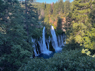
The General Store doesn’t open until 9am, and since I got to Burney Falls a day early, I was in no hurry this morning.  I went to the Visitor Center, where under a covered patio they, nicely, have outside charging outlets.  I started charging up and then played tourist and went to walk around and look at the falls.  Burney Falls is like California’s own miniature version of Niagara Falls, it’s pretty nice.  Then at 9am, it was on to the store to get the things I didn’t get yesterday.

It was another scorcher today, even hotter than yesterday.  Everyone was mentioning how hot it was.  I like to throw people off by saying something like “yeah, there is definitely the potential for it to get hot today.”

Since I was supposed to get to Burney Falls today and spend the night here today, all miles today are bonus miles and may help me get to Shasta City a day early.


Burney Falls


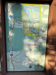
A good map of where I've been the last several days and where I'll be in the next several days.


A Reminder that as far as I've come, there's still a long way to go.


First good look at the massive Mount Shasta


 <--PREVIOUS                                                                                                             NEXT--> 
                                                                                  

PCT Day 76

<--PREVIOUS                                                                                                             NEXT--> 

PCT Day 76, 27 July 2022 (Wednesday)

"Northern CA is the New Southern CA"


Start Location:

Near Hat Creek Rim

Destination:

Burney Falls State Park

PCT Miles Day 76:

25.4

Cum PCT Miles:

1,419.0

Non-PCT Miles Day 76:

1.3

Cum All Miles:

1518.0

PCT Miles Remaining:

1,233.6


Elevation Gain Day 76:

1,140

Cum Elevation Gain:

244,893


The first part of today was continuing to walk along the Hat Creek Rim. This is one long rim trail.  The physical trail was pretty easy today, but the very hot temps made it a strenuous hike in the same way that they were in the hot Southern California desert.

I was on track to get to Burney Falls today, a half day early, and debating whether I should go to the town of Burney—a supposedly very hiker friendly town—or just go to Burney Falls State Park.  I decided it’d be less hassle to just go to the park where there is a general store.  Turned out to be the wrong decision.  I rushed down the trail to get to the Burney Falls General store before they closed, but it just so happened to close a couple hours early today.  No cold sodas, no ice cream, no nothing.  A disappointing end to the day.


Weird, no photos today, guess it was that kind of day.

 
<--PREVIOUS                                                                                                         NEXT--> 


PCT End Of Hike Summary

<--PREVIOUS PCT End Of Hike Summary "A Summary Of My PCT Thru Section Hike"   This is the hardest post to write.  I could prob...